Curacao Cemeteries
Jeff Maass
Updated: 19 September 2020
Introduction and Statement of Purpose
I am interested in visiting and documenting by photographs the cemeteries on the island of Curacao, an island in the southern Caribbean.
I live in Ohio USA, and have traveled
to Curacao on holiday twice a year since 2002. I am
interested in cemeteries
not from the vantage of genealogy, but based upon the history and art revealed
there in the stones and crypts. My "process" is to locate
and visit burial sites and cemeteries, photographing them as I wander through. I
don not claim that my photo albums are complete or particularly organized. I
have recently begun also photographing with a drone to provide a different
perspective. For those that I have not yet visited, where possible, I have included a few photos taken by others.
I keep a spreadsheet with information and rumors on each cemetery and
burial site. I have noted that many of the cemeteries (or their associated churches) do not
have their names indicated. I have attempted to identify each known cemetery
with a name that is descriptive. As the correct name is known, I'll make
corrections. If you are able to help out with information
or images of any of these cemeteries, or of funeral and burial practices on
Curacao, please
email me, and I will add your information and give you credit.
Note that this is a non-commercial site. For more information on the project, Click Here.
There are many discussions of Curacao cemeteries on the web. Here is a page of miscellaneous links to other sites on the web.
To provide information, to offer assistance in accessing cemeteries or burial sites, or to ask questions, I can be reached by email at: jmaass@k8nd.com.
Individual Cemetery & Burial Site Photos and Information
For each cemetery or "candidate cemetery", I have attempted to
provide a drone or Google Earth satellite image, the cemetery name, the location (GPS
coordinates) and a contact person, and an image showing how the cemetery
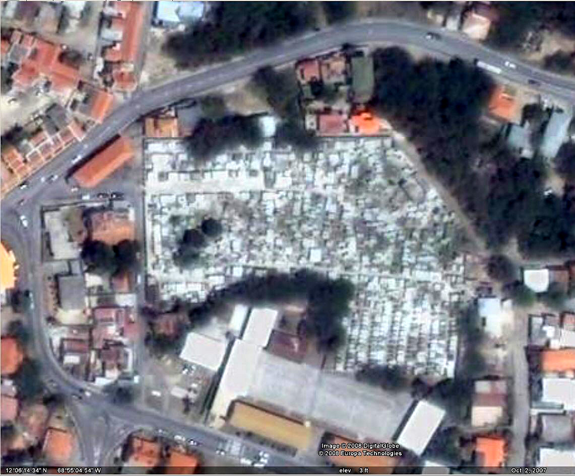
appeared on the Werbata topographical maps published between 1906 and 1910. For
those cemeteries inside Willemstad, a second Werbata map segment may be shown
from the separate city map.
If the cemetery has been photographed, the
name will link to an album of available photos. Click to view.
| Overview Image | Cemetery | Location & Contact |
Notes Please be aware that I am not an authority on the cemeteries of Curacao, just an interested amateur. These are my current understandings, experiences, and research. I welcome corrections or additional information! |
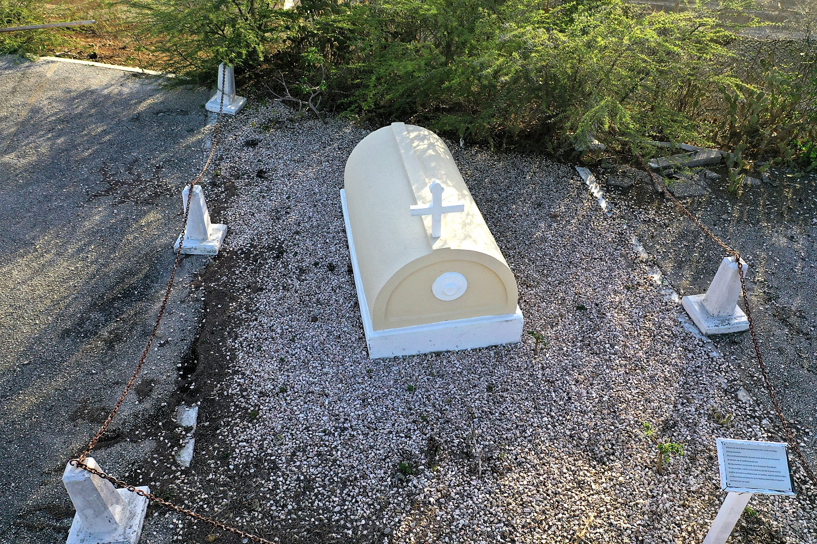 |
Ascencion 'Shon Martin' Grave (GPS: c.Ascencion) |
Landhuis Ascencion 12deg 16' 22.48" N 69deg 3' 48.71" W |
From an article from NAAM (National Archeological Anthropological Memory Management): "At the entrance to the plantation of Ascencion also lies a grave. Here, a certain Shon Martin, the supervisor (“vito”) is believed to lie buried. His last wish was to be buried on his stomach, so that he could continue observing what would become of the plantation. For years his cylinder grave could be seen here, but in the 1980s this grave was cleared with a bulldozer. The Navy who are operating this plantation house, have decided to rebuild the grave. As they did not know how the grave had been built exactly, they first made it into a rectangular grave. But after it had been pointed out how it should be, the Navy gave the grave its original shape." English translation of the information plate at the
site: After his death, he was buried on this place on his stomach, with his head in his hands, looking at the landhouse, so that he would always be aware of the activities at the landhouse and therefore never would find any rest.”(Thanks to M. van der Meulen for translation.) |
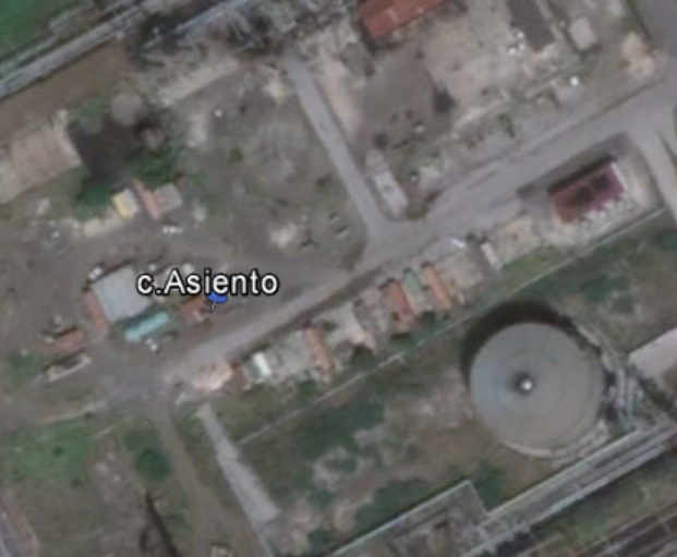 |
Landhuis Asiento (GPS: c.Asiento) |
Willemstad / Blenheim (Isla Refinery) 12deg 8' 1.667" N 68deg 55' 47.58" W It is only accessible with special permission and security provisions. |
NOTE: I have not yet visited/photographed this burial site. Small 3-grave cemetery on the grounds of the former Landhuis Asiento, now completely within the grounds of the refinery. It is only accessible with special permission and security provisions. The cemetery is about 80 metres from the former location of the Landhuis. John Dohman visited and published an article with many photos at http://curacaopictures.com/nl/archeologische-verkenningen/landhuizen/489-twee-bezoeken-aan-de-raffinaderij. From that site: "There is a small walled cemetery with three graves. The first grave is from Charles August count de Larrey, who died on August 13, 1832; the second grave is of his wife Petronella Elisabeth Cameron, who has died on October 22, 1845. It is not entirely clear who is in the third (cylinder) grave lies but there is an indication that there the mullatin Maria Gregoria, also called Peacock or Palmer, is buried." |
|
|
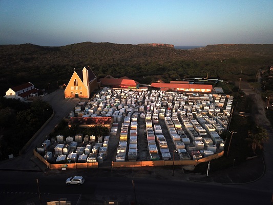
R.K.Begraafplaats Barber Sint Jozefsdal Church (GPS: c.Barber) |
Barber 12deg 17' 22.95 N 69deg 4' 23.20" W Contact: +599 9-864-1798 |
NOTE: I have not yet visited/photographed this burial
site from inside the walls. The main enry to the cemetery is adjacent to the church parking lot on the West side. There are service entries on the South side (on the main road) and on the East side. On the 2015 visit, all gates were locked. In visits in 2016, 2017, 2018, and 2019, all the gates and even and the driveway from the road to the church were locked! So, I have never been able to photograph inside the walls. During first visit in 2009, the cemetery gates were locked but the access road to the church was open, allowing photographing over the fence. Ground photography over the wall January 26, 2009. Drone photography July 9, 2018. |
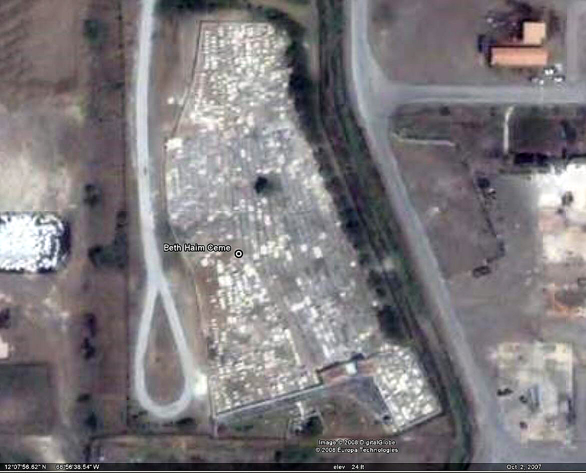 |
Beth Heim / Beit Hayim (Old Jewish) Blenheim (1659 - ?) (GPS: c.BethHeim) |
Blenheim / Willemstad (Isla Refinery) 12deg 7' 53.26" N 68deg 56' 35.33" W Contact: Visits by appointment only (+5999) 461-1067 |
NOTE: I have not yet visited/photographed this burial
site. Old Jewish cemetery, established in 1659 and with the earliest tombstone from 1668. This makes it the oldest Jewish cemetery in the New World. There is much damage to the stones from the Isla refinery gas & particulate pollution, with little of the inscriptions remaining. There is virtually unlimited info on the web about this cemetery. Covered in detail with photos of many of the lost stone inscriptions in the book "Precious Stones: of the Jews of Curacao" by I.S. Emmanuel, published in 1957. |
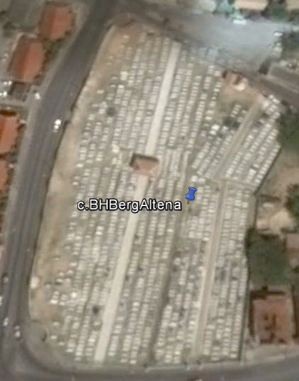 |
Beit Haim Berg Altena Jewish Cemetery (Originally "Ned. Port. Isr." and "Ned. Hero. Isr.") (GPS: c.BHBergAltena) |
Willemstad (Pietermaai) 12deg 6' 14.92" N 68deg 55' 12.51" W Contact: |
This cemetery is still in use. it is located on Berg Altena & Kaya Gutierrez
i Gerardinax. Established in 1864, it was once two adjacent cemeteries divided by a wall, when Mikve Israel (Orthodox) and Emanuel (Reform) were independent from one another, though the wall was removed in 1961 in anticipation of their 1963 reconciliation. Very impressive and expensive monuments: by far the most ornate cemetery seen on Curacao! Ground photography July 10, 2015. Drone photography has not yet been done. |
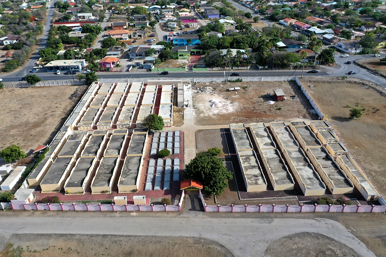 |
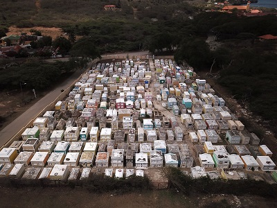
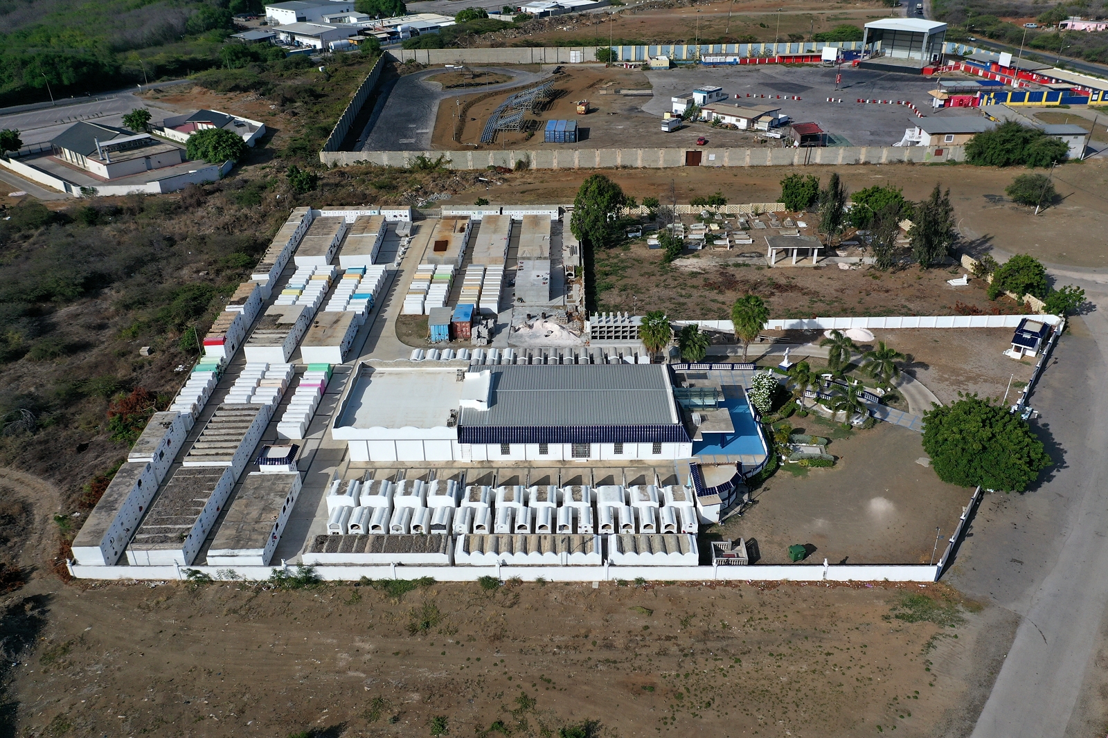
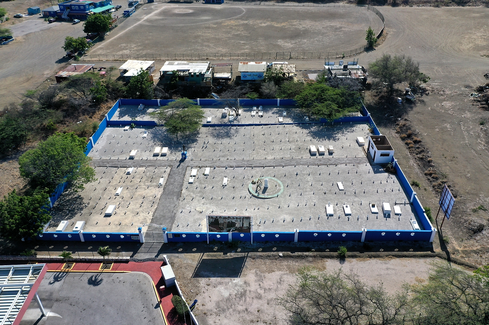
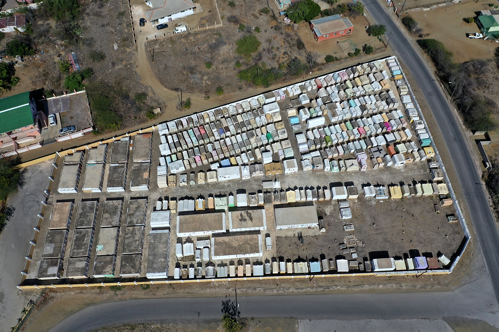
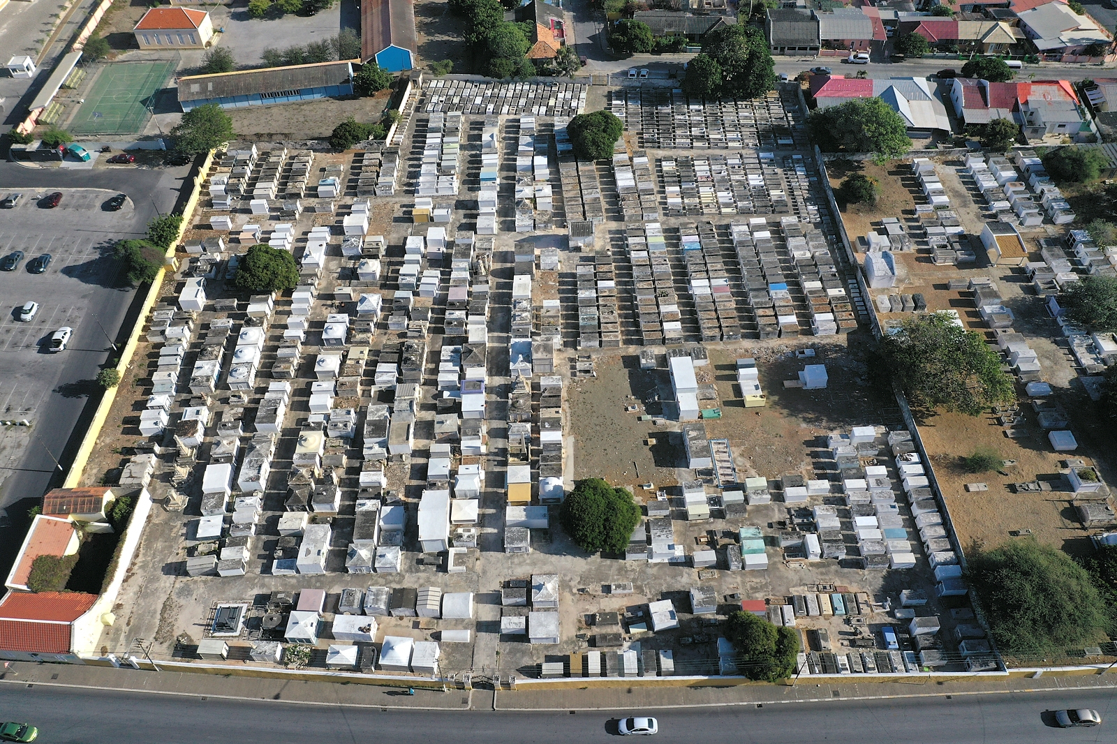
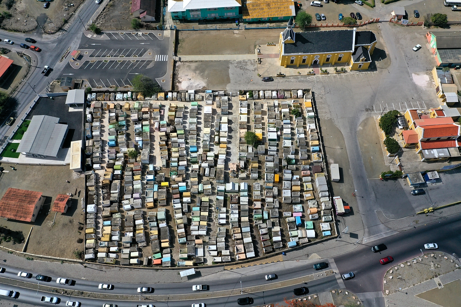
Santana Bethania Brievengat (GPS: c.Bethania) |
Bonamweg at Brievengat Near Festival Center 12deg 9' 7.32" N 68deg 53' 5.05" W Telephone: (+5999) 462-8020 |
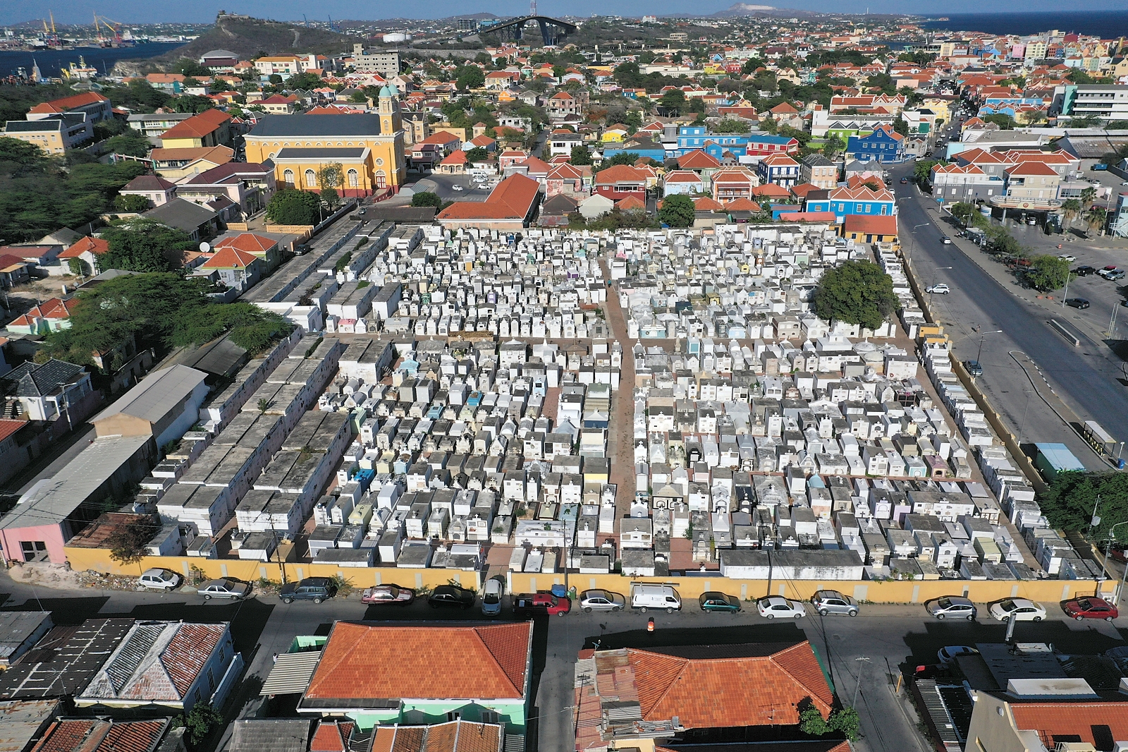
A very "upscale" cemetery in the cluster of four on Bonamweg in
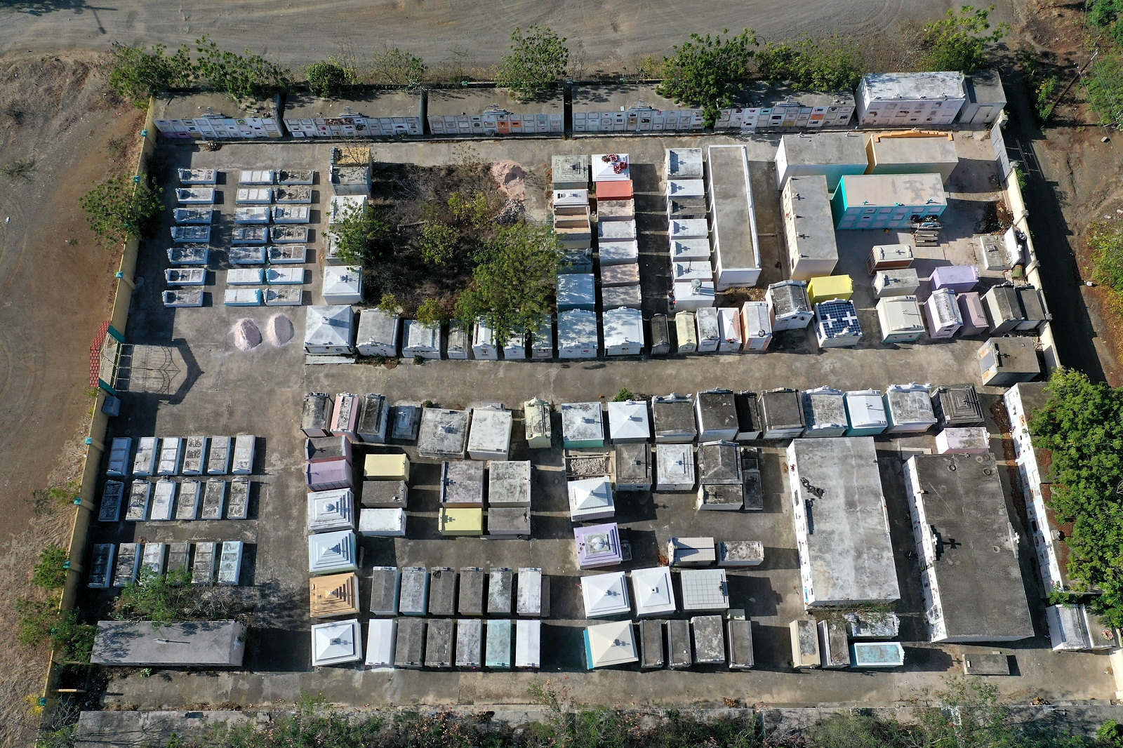
Brievengat. It is walled and normally locked. I was finally able to photograph inside when I found the service gate unlocked and wide open during construction in July 2019. This cemetery has row after row of two-high structures with the same colors and door designs. This is, by far, the most monochrome and least 'personalized' cemetery I have yet seen on Curacao. There are also some expensive-looking marble in-ground crypts, and a few smaller structures likely for cremains. Most of the kalders/crypts are not yet used, and more structures are under construction. Ground photography July 8, 2015 & July 7, 2019. Drone photography July 7, 2019. |
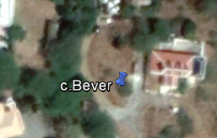 |
Landhuis Bever Oldest two graves on Curacao (1697, 1698) (GPS: c.Bever) |
East Ring Road / Gaitu 12deg 7' 26.33" N 68deg 54' 17.87" W (Private Property) |
NOTE: I have not yet visited/photographed this burial site. This Landhuis was under restoration as of July 2015, and was not accessible when I learned of the graves located there. There are 2 graves behind the house which are among the oldest on Curacao! The house and graves are from the Pietersz family. From Curcao monuments web site: "At the west side of the house are two graves, at the height of the back gallery and shifted relative to each other. The foot ends are oriented to the east. The tombstones are made of blue stone. Near the house is the oldest grave: [oval bas-relief with weaponry] / "Here lays buried / Jan Pietersz from Oxford / Cornet on Ruyterye / obiit 29. Febr: 1684. // With sijn Huys Female / JOHANNA MATTIAS / obiit 27 April 1698 ". The second tomb is located northwest of the first. It also has an oval bas-relief with weaponry, "Here lays buried / THOMAS Pietersz. / Cornet on Ruyterye. / Obiit 3 Feb: 1697 " http://www.curacaomonuments.org/drov-information.php?geo_code=439001 |
 |
La Birgen del Carmen Roman Catholic Cemetery (GPS: c.BirgenCarmen) |
Groot Kwartier / Weis 12deg 8' 42.64" N 68deg 54' 43.83" W Telephone: +599 9-737-4467 |
Adjacent to La Birgen del Carmen Roman Catholic Church on Montezumaweg. There is an unlocked gate on church side of the walled cemetery. The cemetery is surrounded by tall walls topped by shards of jagged glass! Walls or fencings around cemetries are required by law. (Art.16 lid 1 Begrafenisverordening: 'Elke begraafplaats wordt door een muur, heining, rasterwerk of heg ter hoogte van ten minste twee Meter afgesloten.')" Ground photography July 4 & 9, 2015. Drone photography July 9, 2019. |
 |
Morada Santa - Bottilier (GPS: c.Bottelier) |
Bottilier 12deg 6' 6.48" N 68deg 53' 0.72" W |
A modern upscale
non-denominational cemetery, still in use. Reportedly, several prominent authors in the Papiamentu language are buried here.There is a large memorial to 'Doktoor Moises Frumencio da Costa Gomez (1907-1966)', with crypt, large bust, and panels, all on a raised platform. Very "upscale", with much marble in the crypts. Many graves bearing chinese characters and names, and many graves with Papiamentu text. The earliest burials noted were mid-1970s. Striking is the number of trees present and many benches provided for the comfort of visitors inside the sprawling grounds. Has a chapel inside the gates with crypts mounted along length and width of each of the longest walls. Not easy to find, it is not on a main road, and access is via dirt road running next to strip mall, or via a dirt road accessible from adjacent residential area. Ground photography July 5, 2016. Drone photography July 11, 2019. |
 |
Parke el Consolador Brievengat (GPS: c.Consolador) |
Bonamweg at Brievengat Near Festival Center 12deg 9' 7.38" N 68deg 53' 2.64" W
Agencia Funeraria `El Consolador`
|
NOTE: I have not yet visited/photographed this burial site from inside the
wall. A very "upscale" cemetery in the cluster of four on Bonamweg in Brievengat. There is a large indoor mausoleum. Ground photography through the gate July 8, 2015. Drone photography July 7, 2019. |
 |
Crefona Curacao (Crematorium) Brievengat (GPS: c.Crefona) |
Kaya Willfred Pieters at Brievengat 12deg 09' 13.44" N 68deg 53' 1.08 W |
Crefona Curacao is a funeral
home and crematorium,
located near the cluster of four cemeteries on Bonamweg in Brievengat. I have photographed it only from the outside of the buildings, and do not plan to photograph inside. Ground photography outside July 7, 2019. Drone photography July 7, 2019. |
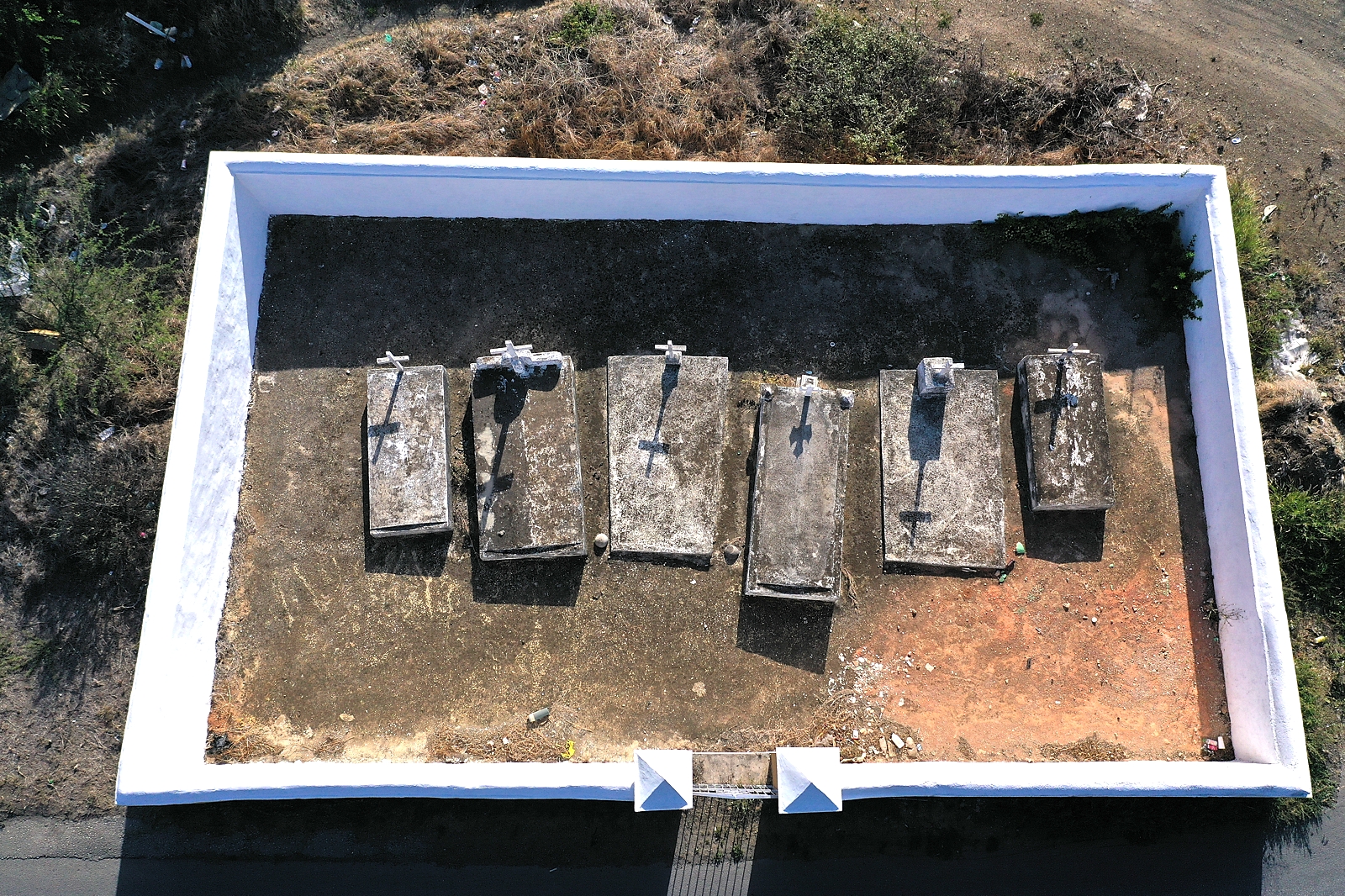 |
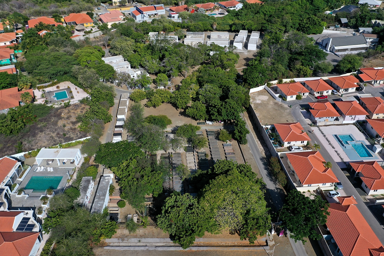
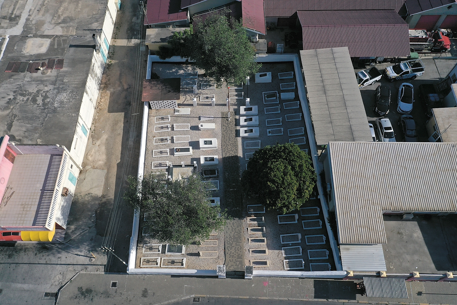
de Windt Family
Cemetery Sun Valley (GPS: c.deWindt) |
Sun Valley 12deg 9' 29.69" N 68deg 54' 19.408" W |
This is a family cemetery for the de Windt family, who were the owners of Landhuis Noordkant. There are six graves, only one of which (on the far right) has identifying information. The plate on the cross reads: "Lorenzo F. de Windt NACIO 21.5.1893 FALL 22.4.1955 R.I.P." They are enclosed in a 50 x 30 foot space by a low wall with a gate, which although not locked was firmly stuck in the closed position. It is located in Sun Valley on Commandeursweg. The front wall is mere feet (inches, really) from a very active roadway. These photos were taken over the wall, which varies in height above sloping ground. Ground photography July 7, 2019. Drone photography July 11, 2019. |
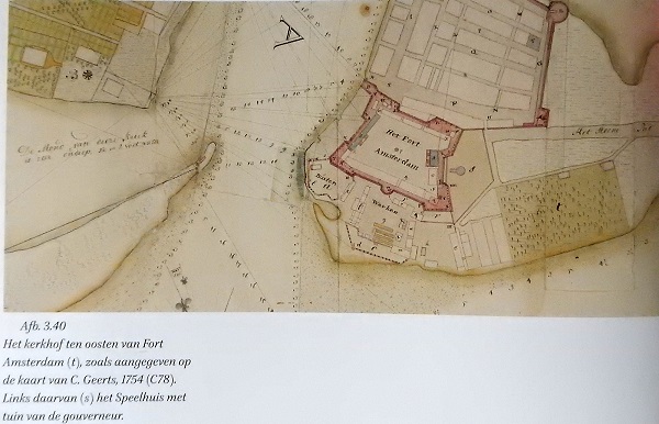 |
Begraafplaats Fo'I Porta (GPS: c.FoiPorta) (DESTROYED / MOVED / BUILT OVER) |
Site of Temple Emanu-El /
Public Prosecutor’s Office Area Punda, Willemstad 12deg 6' 12.55" N 68deg 55' 57.22" W |
NOTE: This cemetery has been moved / destroyed / built over. A Dutch Protestant burial ground established "outside the gate" ("Fo'I Porta) of Fort Amsterdam in 1635. This graveyard was clearly documented as being primarily for the burial of soldiers, both Dutch and other European, as well as Protestant colonists of more modest means, not the elites After a hurricane in 1807 exposed some of the bodies buried there, it was directed by then then-British government that families should exhume the graves in preparation for a clearingof the area. Reportedly, many of those removed were buried in the Protestant cemetery in Oranjestraat. By 1812, the British had established an open-air meat market there! From 1865-67, the Temple Emanu-El was constructed on a part of the site. During restoration in 1998, graves were exposed below the Temple structure, and archaeology was undertaken. The building was later converted to use as the offices of the Public Prosecutor. An excelent article (in English) describing the history of the site and the excavation of the graves is "HISTORY, ARCHAEOLOGY, AND PHYSICAL ANTHROPOLOGY OF DUTCH PROTESTANT SKELETAL REMAINS FROM “DE TEMPEL” SITE, CURACAO" by Jay B. Haviser, M. Rakieb Khudabux and Els Langenfeld. Another report, in Dutch, is "Rapportage Archeologische begeleiding Wilhelminaplein/Waterfortstraat, 5 mei tot en met 2 juni 2006, in opdracht van Stichting NAAM mede gefinancierd door Monumentenzorg en Curaçao Tourist Board" by Claudia Kraan. (Thanks to Claudia Kraan for providing copies of these fascinating reports!) |
 |
Fontain-Sumbu (GPS: c.Fontein) |
Inside Villapark Fontain 12deg 15' 4.457" N 69deg 3' 41.825" W |
NOTE: I have not yet visited/photographed this burial site. From Thijs van Uijtregt 170417 on behalf of Stichting Uniek Curacao. "Little is known and documented about the grave, so I cannot answer all your questions, but this is what I know:The grave is in very poor condition and needed to be restored. It is not with certainty to say who is in the grave, but the probability that it was one of the owners of the former plantation is greatest. The plain where the grave is located was farmland in colonial times. This area was also the last battlefield of the Curaçao Slave Revolt of 1795. After this battle there are several insurgents executed in the area. The area is easily accessible on foot, and from Villapark Fontein it is about 900 meters (follow the yellow bricks).The enclosure shows a picture of the grave, maybe this can tell you more. (Single photo of very-deteriorated grave provided: in file). I hope I have answered all your questions. If you would like to know more of the grave, I refer you to François van der Hoeven (francoisvanderhoeven@gmail.com). François has done a lot of research in the area and you can probably tell you more." |
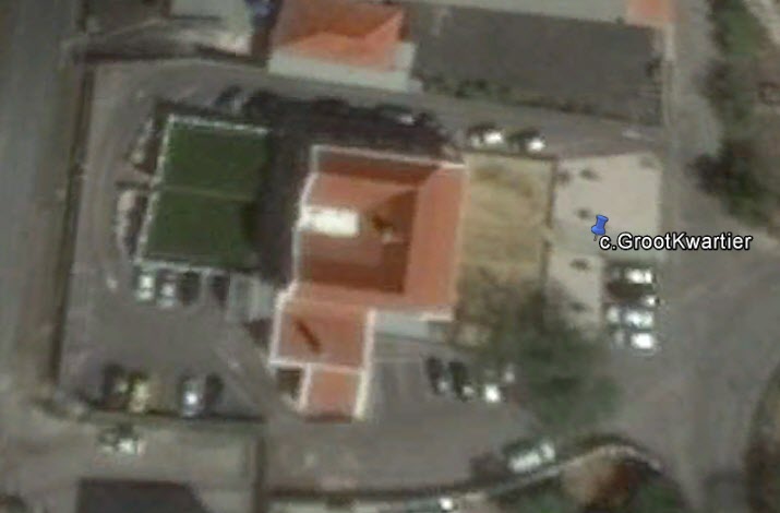 |
Groot Kwartier (GPS: c.GrootKwartier) |
Groot Kwartierweg 18 12deg 7' 48.36" N 68deg 54' 26.04" W |
There is one grave in front of Landhuis Groot Kwartier, which is now owned by Trustmore, which uses it as an office building. Unfortunately, at the time I photographed in July 2016, someone had hit the chain and supports surrounding the grave, and have knocked down those close to the driveway. No damage was done to the grave itself. The inscription reads: "The grave of Cortland Lewis Parker, Born 15 June 1781 at Shipley - New Jersey - U.S., Died 12 February 1826. There is reported a second inscription (cenotaph?), but it is not visible. It is reported as: "In Memory of Pieter Washington van Steenberchg, Who Departed This Life March 12, 1808, Aged Seventeen Months and five days." Ground photography July 7, 2016. I have not yet photographed with the drone. |
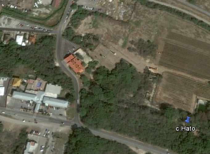 |
Landhuis Hato Evertsz Family Cemetery (Early 19th Century) (GPS: c.Hato) |
Hato, East of Airport 12deg 10' 53.64" N 68deg 56' 56.52" W Contact: Curacao Winery 599 9-512-3542 info@curacaowine.com |
When I visited and photographed in 2015, Curacao Airport Holding (CAH) had renovated Landhuis Hato, and it was being used as Curacao Winery. The site includes small walled cemetery with 7 graves from the early 1800s. [NOTE: As of 2017, the Winery is no longer leasing the site. Access to the cemetery is uncertain.] Located East of airport, 50 meters North of the airport road. The crypts were located next to the vinyard (or, where it was), and is a ~1/2-mile walk from the Landhuis building. Five of the graves are of the half-cylinder type, two are rectangular and are of the Evertsz family. One of the graves is long-ago collapsed. Included is Cornelius Gerardus Evertsz, who was killed defending during the attack by the English January 1, 1807. Ground photography July 5, 2019. Drone photography will never be possible, due to proximity to the airport (and full tree cover). |
 |
Hellmund - de Veer Family Cemetery (GPS: c.Hellmund) |
Otrabanda / Willemstad (Roodeweg) 12deg 6' 45.31" N 68deg 56' 39.49" W Contact: |
NOTE: I have not yet visited/photographed this
burial site. This small (~12 crypts) family cemetery is inside the outer wall on the NW corner of the Masonic cemetery on Rodeweg. It is enclosed in a white wall that is inside the outer wall, and separates it from the Masonic part. It has a separate entry gate, and (possibly) a nondescript green door (which may open into the Masonic cemetery instead). Discussion on Facebook (190819) identifies it as a family cemetery that predates the Masonic. Chrystal Monsanto ('Christopher Massur") has photographed inside, and reports that the names reflect Hellmund and de Veer familiies. While I have not yet photographed this cemetery, Carel Haseth has posted an album at: https://careldehaseth.smugmug.com/Grafstenen/Kerkhof-Hellmund/ |
 |
Jandoret Catholic (GPS: c.Jandoret) |
Sint Michiel - Weg Naar Bullenbaai 12deg 8' 57.78" N 68deg 58' 36.93" W |
This Catholic cemetery is in the central part of the island on Weg Naar
Bullenbaai. This is a modern cemetery still in use, and with plenty of room for expansion. The gate was latched but not locked when visited. Ground photography July 4, 2016. Drone photography July 8, 2019. |
 |
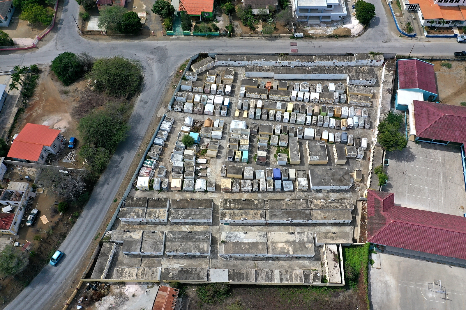
Janwe Catholic Cemetery "Santana Katoliko Parokia di Janwe" (GPS: c.Janwe1) |
Janwe Seru Loraweg at Janwestraat 12deg 6' 34.67" N 68deg 53' 43.93" W |
This is the older (earliest date
seen was 1932) of the two connected Catholic cemeteries at Janwe (the other
is Janwe-Pietermaai Catholic Cemetery - "Santana Katoliko
Janwe-Pietermaai"), at Seru Loraweg and Nieu Caracasbaaiweg. This cemetery
is the one on the Southwest side of the walled cemeteries, and is roughly
250 x 210 feet in size. They each have their own entry gates, and a central wall separates the two. While there is a door through the central wall at the NW corner, it is overgrown and blocked (see photo 'Janwe1_2756'), and clearly has not been used for a long time. The gate for this cemetery is on the SW wall, and appears to be open from 8 AM to 6 PM, according to sign painted on pillar at the gate. Gate was unlocked when seen. Ground photography July 7 & 9, 2019. Drone photography July 9, 2019. |
 |
Janwe-Pietermaai Catholic Cemetery "Santana Katoliko Janwe-Pietermaai" (GPS: c.Janwe2) |
Janwe Seru Loraweg at Janwestraat 12deg 6' 35.96" N 68deg 53' 43.60" W |
This
is the larger and newer (earliest date seen was 1950) of the two connected Catholic cemeteries at Janwe (the other is Janwe Catholic Cemetery
- "Santana Katoliko Parokia di Janwe"), at Seru Loraweg and Nieu Caracasbaaiweg. This is the
more "high end" of the two cemeteries, with many large and ornate family
structures. This cemetery is the one on the Northeast side of the walled
cemeteries, and is roughly 250 x 290 feet in size. They each have their own entry gates, and a central wall seperates the two. While there is a door through the central wall at the NW corner, it is overgrown and blocked (see photo 'Janwe1_2756'), and clearly has not been used for a long time. The gate for this cemetery is on the NW wall.This cemetery is associated with Maria Magdealena RK Santana in Berg Altena (c.MariaMag). Ground photography July 9, 2019. Drone photography July 9, 2019. |
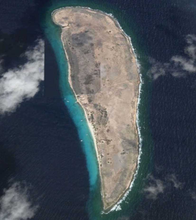 |
Klein Curacao (GPS: c.KleinCur) |
Klein Curacao Island 11deg 58.864 N 68deg 38.545 W (Very Approximate) |
NOTE: I have not yet visited/photographed this burial site. Saw reference 200810 that there is "a handful of graves still visible on the South end" of Klein Curacao island, approximately 7.5 miles from the SE tip of Curacao. Buried on this small island were believed to be shipwreck victims and slaves who died on the transit from Africa. Reports on Facebook are that there are no visible signs of these graves remaining, although, so confirmation either way would be welcomed. |
 |
Santana Kolebra Berde (National Monument) (GPS: c.Kolebra) |
Kas Chikitu 12deg 7.817' N 68deg 57.217' W |
National monument, with mass grave of 15 Chinese sailors working for Shell
Oil who were shot during demonstrations 20 April 1942. They were protesting
the dangerous conditions of their service on merchant ships. They were
buried in this cemetery, which was unconsecrated and generally used for
prostitutes and criminals ("...a profane field where vagrants, prostitutes,
stillborn children and other nations buried.") The cemetery/monument is reportedly often closed (locked). Restored and consecrated in 2003. Ground photography July 4, 2016. Drone photography July 12, 2019. |
 |
Maria Magdealena Santana Berg Altena Roman Catholic Cemetery (GPS: c.MariaMag) |
Willemstad (Pietermaai) 12deg 6' 13.85" N 68deg 55' 1.64" W
email: kisba2009@hotmail.com |
On Berg Altena/Riouwstraat South of Kamina Salina, a bit East of the Jewish Beit Heim Berg Altena cemetery. Ground photography July 10, 2015. I have not yet photographed with the drone. |
 |
Masonic Cemetery
Universelle (GPS: c.Masonic) |
Otrabanda / Willemstad (Roodeweg) 12deg 6' 42.67" N 68deg 56' 36.00" W Contact: |
NOTE: I have not yet visited/photographed this burial site. This Masonic cemetery is on Roodeweg, just West of the Protestant cemetery, with which it shares a separating wall. There are three entry gates (East to West): the main gate, an iron gate with Masonic symbol; a nondescript green door; and a large gate. The Western-most gate opens into a separately-walled section with perhaps a dozen crypts, but separated from the rest of the cemetery inside the outer wall by a white interior wall. This is the Hellmund / de Veer family cemetery, which pre-dated the Masonic cemetery. It will be listed separatesly as more information is received. Drone photography July 12, 2019. I have not yet photographed inside this cemetery. |
 |
Militaire Begraafplaats (GPS: c.Militaire) |
Otrabanda, Willemstad (Roodeweg) 12deg 6' 48.39" N 68deg 56' 49.87 W
Contacts: |
A military cemetery on Roodeweg in Otrabanda, next to the fire station. It was restored in 2006, and is maintained by by volunteer members of SMEC (Foundation Military Heritage Curaçao). Burials date from the 19th centrury, and include military members from several countries who died on or in the vicinity of Curacao. The gate is normally locked, but there are regular sessions on the first Saturday morning of each month to clean and maintain the site, and they are welcoming of visitors interested in learning about the local military history represented by cemetery. A drone video starting just West of this cemetery and flying East along Roodeweg to the vicinity of the other three cemeteries on this road can be viewed at: https://www.youtube.com/watch?v=U2hp8wJMb1I Ground photography July 6, 2019. Drone photography July 12, 2019. *** Other people's photos linked below: Photos of the restoration of this cemetery are available at http://www.debakstafel.nl/de-roodeweg-2014.html A good-quality video exploration of this cemetery is on YouTube at https://www.youtube.com/watch?v=P75kiAdeHsc A low-resolution video of this cemetery is on YouTube at https://www.youtube.com/watch?v=nZjmq6Vz3HA |
 |
Montana
(Catholic) Parokia San Dominiko (GPS: c.Montana) |
Montana -
Stakamahachiweg 12deg 6' 18.36" N 68deg 53' 53.36" W Contact |
A medium-sized Catholic cementery adjacent to the church. To get to the cemetery gate, enter the church parking lot and go to the back. The gate was unlocked on my visit, but the lock shows signs that it has been used regularly. Common among the crypts are some with half-cylinder tops. The molds for these were found in back of some crypts.At the center of the cemetery is the crypt of Monsignor Julio F. Henriquez (1908 - 1998), topped by a tall white cross. The gate is topped by the words "Sosega Napaz" ("Rest in Peace" in Papiamento). Ground photography July 6, 2016. Drone photography July 11, 2019. |
 |
Muslim Brievengat (GPS: c.Muslim) |
Bonamweg at Brievengat Near Festival Center 12deg 9' 7.62" N 68deg 53' 5.04" W (Shares two walls with Parke el Consolidor) |
NOTE: I have not yet visited/photographed this burial site from inside the
wall. This cemetery is one in the cluster of four on Bonamweg in Brievengat. This cemetery appeared to be newly-built in 2015 when I visited. There were just a few newly-established in-ground graves. There was no identification of a name for this area, but it was separated from Parke El Consolidor by wall(s). I later learned that it is a Muslim cemetery. Ground photography through the gate July 8, 2015. Drone photography July 7, 2019. |
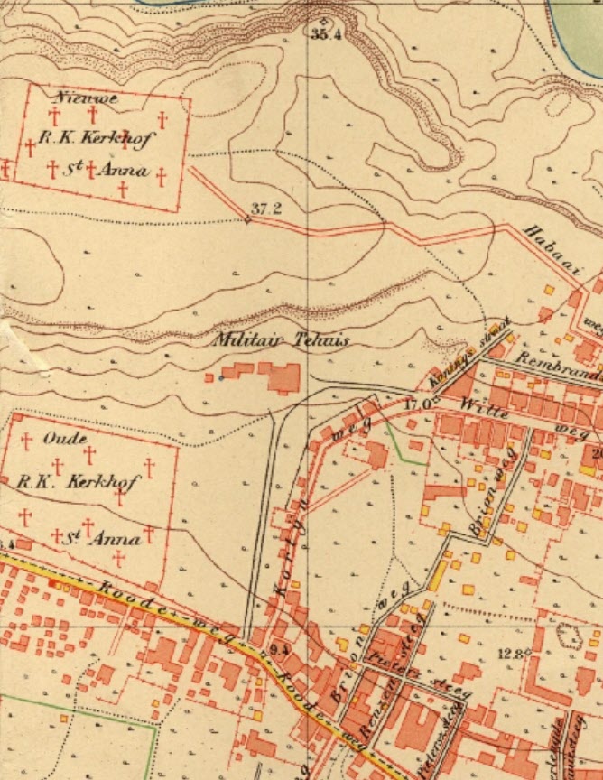 |
New St. Anna Roman Catholic "Nieuwe R.K. Kerkhof St. Anna" (GPS: c.NewStaAnna) DESTROYED / MOVED / BUILT OVER) |
Willemstad (Domi) 12deg 6' 55.93" 68deg 56' 29.94" DESTROYED |
NOTE: This cemetery has been moved / destroyed / built over. This cemetery was shown on the 1906 Werbata maps (see image, top left), but was destroyed/removed sometime in the 1990s. I'm not sure what the procedure is on Curacao for 'decommissioning' a cemetery. I have heard that the families were allowed to take the information plates from the crypts of their relatives. I have not heard whether the contents of the crypts were transferred to another cemetery. More information from those affected would be welcomed. The site is now a BMW/Hyundai car dealership. |
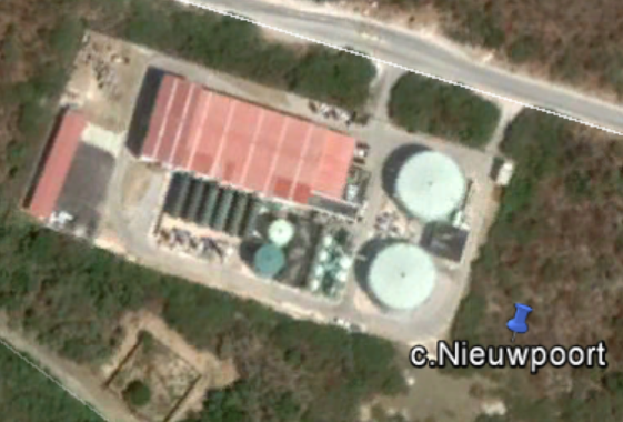 |
Begraafplaats Nieuwpoort (GPS: c.Nieuwpoort) |
Nieuwpoort / Fuik /Mijnmaatschappij 12deg 3' 14.87" N 68deg 49' 35.66" W Restricted Access - Gate Pass Required |
NOTE: I
have not yet visited/photographed this burial site. This site is in a secured area because it is a large mining area and Aqualectra facility, and one must pass a security gate to access. . Secured . There are just 4 graves in total and only three are legible. John Dohman has reported detail about this burial site: https://curacaopictures.com/nl/archeologische-verkenningen/mijnen/596-nieuwpoort-het-kerkhofje?fbclid=IwAR1o3gxQ_J7b_MxkAV_0RH-lRT-zgU-h44XkLy3n8HToMerfZP9vPUOrcVo |
 |
Old St. Anna Roman Catholic "Oude R.K. Kerkhof St. Anna" (GPS: c.OldStaAnna) |
Otrabanda / Willemstad (Roodeweg) 12deg 6' 45.97" N 68deg 56' 31.08" W Contact: |
NOTE: I have not yet visited/photographed this burial site. Probably the oldest Catholic cemetery on Curacao, and one of the largest. Located across Roodeweg from the Protestant cemetery. Between Roodeweg & Volksbondstraat. There is an office adjacent to a gate on Roodeweg. Drone photography July 12, 2019. I have not yet photographed inside this cemetery. |
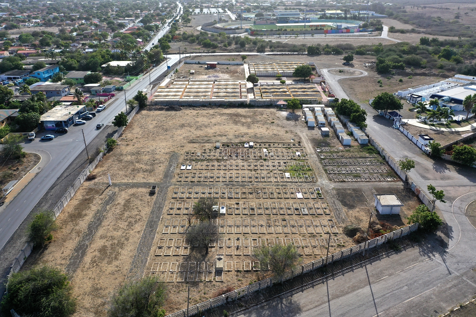 |
De
Openbare Begraafplaats (Public Cemetery) Brievengat (GPS: c.Openbare) |
Bonamweg at Brievengat Near Festival Center 12deg 9' 6.72" N 68deg 53' 1.26" W |
This cemetery is one in the cluster of four on
Bonamweg in Brievengat. This is a public cemetery for those who do not have funds for burial at private expense. Most of the graves are in-ground and are not marked with names or dates, only a plot number. Those which have markers are low-cost and generally home-made. Most of the in-ground plots appear to be from the late 1960s and 1970s, although those in the above-ground mausoleums are date in the 2000's. Ground photography July 8, 2015. Drone photography July 7, 2019. |
 |
Oranjestraat Protestant (GPS: c.ProtOranje) |
Willemstad (Pietermaai) Berg Altena & Oranjestraat 12deg 6' 10.30" N 68deg 55' 21.04" W Contact: |
Located at Berg Altena & Oranjestraat, just downhill from the often-photographed row of colorful houses on Berg Altena. A medium-sized cemetery, there is an unlocked gate on Berg Altena that appears to never be locked, and one gate that appears to be normally locked on the Oranjestraat side. Nearest parking, unfortunately, is on the side of the cemetery away from the unlocked gate, in an alley on the other side of the adjacent building! Earliest burial noted was from the 1830s. Carel de Haseth photographed and published a web page with all of the identiying markers in this cemetnery, and it is online at https://careldehaseth.smugmug.com/Grafstenen/Oranjestraat/ Ground photography July 2, 2016. I have not yet photographed with the drone. |
 |
Patrick (GPS: c.Patrick) |
Dokterstuin 12deg 17' 11.0724" N 69deg 3' 52.2576" W |
NOTE: I have not yet visited/photographed this burial
site. These are indicated by two red crosses on 1906 Werbata map "05a_V.jpg". Actual GPS coordinates provided by John Dohman of 'Stichting Uniek Curacao'. These are three cylindrical graves in serious disrepair. |
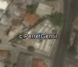 |
Perret-Gentil Family Cemetery (GPS: c.PerretGentil) |
Willemstad (Pietermaai) 12deg 6' 18.40" N 68deg 55' 14.11" W |
NOTE: I have not yet photographed this burial site from inside the
wall. This small family cemetery is located on Kaya Gutierrez I Gerardina, just NW of the Jewish Cemetery on Berg Altena. Visited and photographed from outside, through chain-link fence and over wall, as the gate was locked. Ground photography July 9, 2018. Drone photography has not yet been done. |
 |
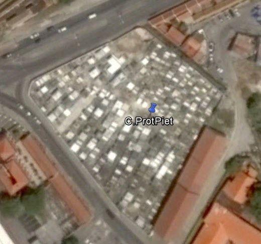
Protestant Roodeweg (Otrabanda) (GPS: c.ProtRood) |
Otrabanda / Willemstad (Roodeweg) 12deg 6' 42.67" N 68deg 56' 36.00" W Contact: |
This cemetery is located on Roodeweg, adjacent to the Masonic cemetery,
sharing a dividing wall to the West. The cemetery appears to be locked, but it is a ruse according to the Protestant Church staff: the lock on the main gate is not locked, and the chain can be removed. Place it back in that state during and after a visit. During my visit July 11, 2016, the rear gate was wide open, with no pretense of locking. Formerly, the key could be asked for at the office tot he left (East) of the cemetery, but that office is now closed and for rent. My visit 160711 was abbreviated, and a return trip is planned for more thorough photography. Ground photography July 11, 2016. Drone photography July 12, 2019. |
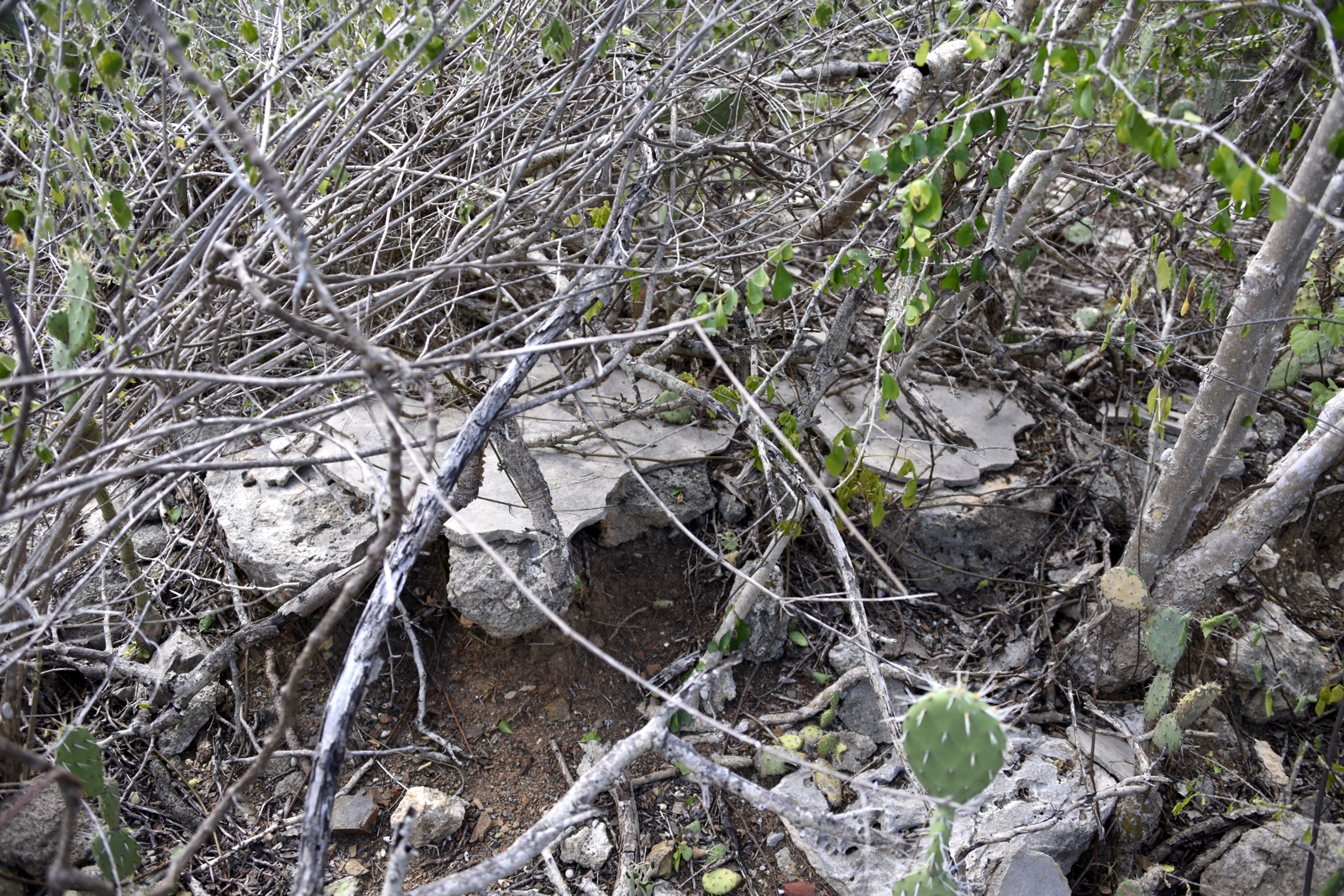 |
Landhuis Rif St. Marie (GPS: c.RifStMarie) |
12deg 12.350 N 69deg 03.888 W |
Two
deteriorated graves at ruins of Landhuis Rif St. Marie near Willibrordus.
One of these is likely for two people. One of those buried here is Carel
Zacharias de Haseth, an owner of the Landhuis. The graves are hidden in the wabi on the West side of the roadway, about 200 feet from the landhuis. A small pile of rocks at the side of the road marks the slightly-worn path back to grave site, about 25 feet off of the road. As I don't disturb graves or surrounding terrain as found, they are difficult to see in the photographs. Ground photography January 31, 2020. Drone photography not possible, as the Rif St. Marie is a drone 'No Fly Zone' to protect the flamingo population. |
|
Landhuis Rif St. Marie - Anna (GPS: c.RifStMarieAnna) |
12deg 11.8798 N 69deg 03.9868 W (Coordinates Approximate) |
NOTE: I have not yet photographed this burial
site. A 2-meter long cylinder grave, much deteriorated. This is reportedly the grave of a child named 'Anna', whose parents lived in the landhuis at the time. They left the island soon after. It is not known why the grave is a long as it is, given that it is for a child. It s located near the ruins of indigo production structures on the South side of the salina, reportedly near the road. It is about 1/2-mile South of the landhuis. A report of a 2011 visit to the landhuis and with photos of this grave and the nearby grave of 'Anna' is online at https://curacaopictures.com/nl/archeologische-verkenningen/landhuizen/196-rif-st-marie?fbclid=IwAR3F8JQf0mFFxJmCRmZIl7reOy17CWaRembIAlx0CKg63pc-5MgIn2H5pHg. Drone photography not possible, as the Rif St. Marie is a drone 'No Fly Zone' to protect the flamingo population. |
|
 |
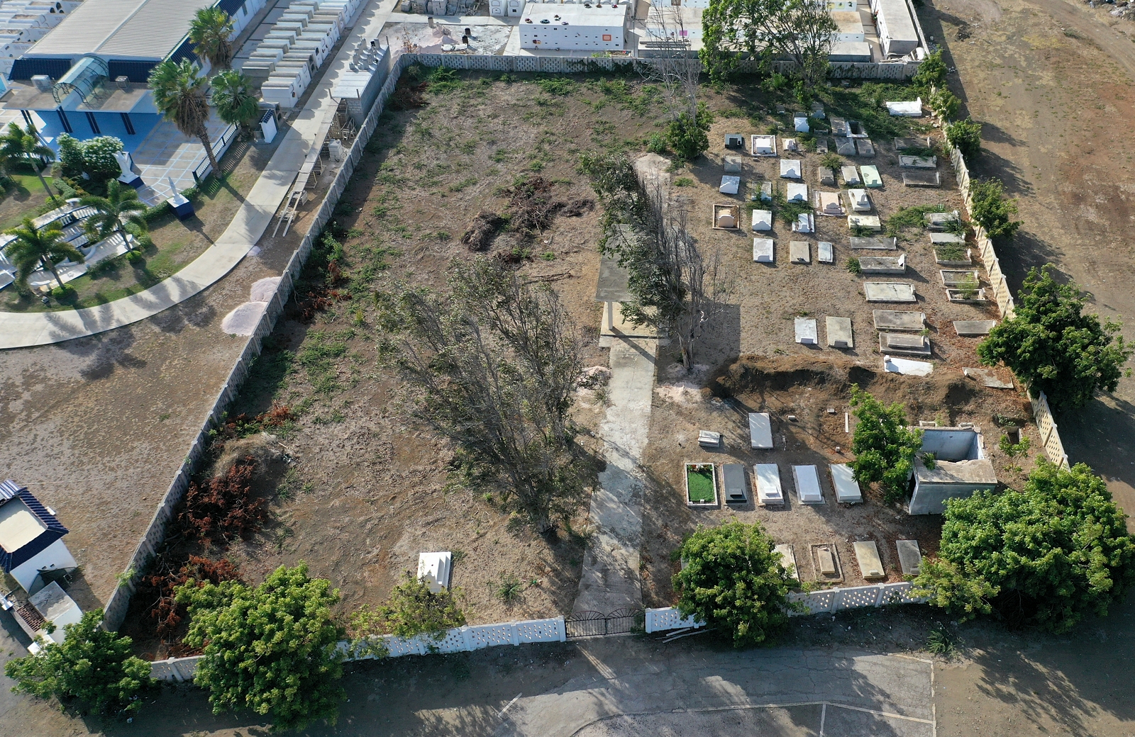
Sisters of Roosendaal Cemetery
"Begraafplaats van Zusters Roosendaal" (GPS: c.Roosendaal) |
NW of Landhuis Habaai Weg naar Welgelegen 12deg 7.3990' N 68deg 57.0468' W |
On Weg
naar Welgelegen 9, NW of Landhuis Habaai. The cemetery is not visible from
the road. On the grounds of 'Fundashon Birgen Di Rosario', a facility for the elderly known as 'Huize Welgelegen' or just 'Habaii'. It was formerly a convent of the Franciscan Sisters of Roodendaal, and the cemetery dates to then and may well be in current use for new interments. The convent was donated to the Fundashon for the current purpose. There is no mention on their web page about the cemetery. The cemetery may be accessed from the driveway/access road to 'Huize Welgelegen', past the guardhouse. A side road to the right leads to the cemetery and to 'Hofi Wayaka', a 'party house' facility rented out. Email address for Fundashon Birgen Di Rosario: 'birgen@birgendirosario.com' . Ground photography (from outside the wall) February 2, 2020. |
|
Rosentak (Roostak) Cemetery (GPS: c.Rosentak) |
Blenheim / Willemstad (Isla Refinery) ,Adjacent to Beit Heim Jewish Cemetery 12deg 7' 51.28" N 68deg 56' 34.94" W |
NOTE: I have not yet visited/photographed this burial site. Family cemetery for owners of Landhuis Rosentak (also known as Roostak). Original burial site of Admiral Pedro Luis Brión (July 6, 1782, Curaçao – September 27, 1821, Curaçao), Venezuelan hero, whose body was later relocated to Venezuela. Also contains members of family Lauffer. Report is that the gate to this cemetery has been found to be locked. Photos: https://michelevanveldhoven.smugmug.com/Curaçao/2011/RoostakRosentak-Graveyard-of-the-family-Brion/i-cHGXB8w/A |
|
|
San Hieronimo William Foote Grave (GPS: c.SanHier) |
In St. Christoffel Park Plantation of San Hieronimo 12deg 19' 1.50" N 69deg 6' 2.52" W PRIVATE PROPERTY |
NOTE: I have not yet visited/photographed this burial site. Info from NAAM. Single grave "...just across the fence of Christoffel Park, at the plantation of San Hieronimo, near the old copper mine, is the grave of an Englishman, a small rectangular monument built of natural stones and bricks. On the East side of this grave is written 'Sacred to the memory of William Foot of Horrabridge, Devon England Born May 26th 1846'. On the North side: 'H.W. Toop' On the South side: 'Erected by J.G. 1880'. On the West sied: 'Died on this estate July 25, 1879, Aged 33 years. his end was peace.' ". (From: 'document.naam.cw/en/_doc/Graves+and+cemeteries+') Note from 'Landhouses of Curacao', the site of the landhuis is accessible only with the permission of the landowner. PRIVATE PROPERTY |
|
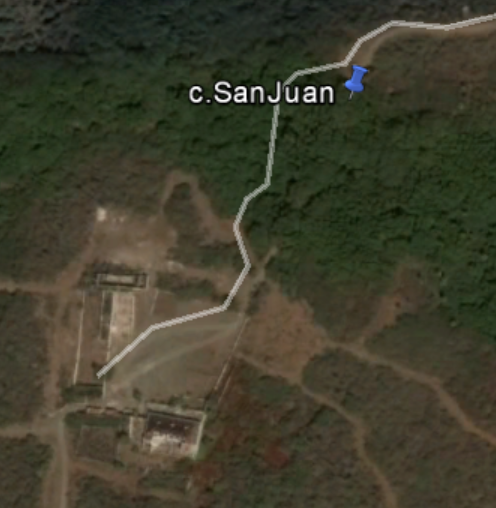 |
San Juan Grave Matthias Schotborgh Single Grave Died 1913 (GPS: c.SanJuan) |
Near Lanhuis San Juan 12deg 15' 17.42" N 69deg 5' 51.34" W Very Approximate Coordinates PRIVATE PROPERTY |
NOTE: I
have not yet visited/photographed this burial site. Info from NAAM. Single grave burial on private land. "Along the way to the plantation house of San Juan, you can see among the plants a low-built rectangle: a grave. There are no inscriptions on the grave. Here lies Mattias Schotborgh (1832-1913), one of the former owners of San Juan." (From 'document.naam.cw/en/_doc/Graves+and+cemeteries+') |
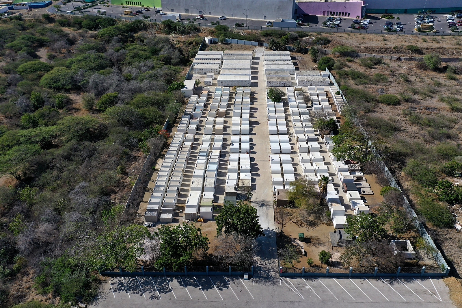 |
El Senorial Memorial Park (GPS: c.Senorial) |
On Veerisweg 12deg 7' 56.04" N 68deg 57' 27.50" W |
A modern cemetery, established
in 1997, located just south of the Sambil Mall in Veeris. This cemetery is
owned by one of the mortuaries on the island. Construction of new kalder structures was underway during my visit, but the gate may normally be locked. There are many unused kalders availalble for new burials. A sign on the the gatepost says: "It is not allowed to drive to the cemetery with motor vehicles. We want to remind our kalder owners that an annual contribution is due for the maintenance of the cemetery. Please adhere to it." The cemetery is clean and well maintained. Ground photography July 8, 2019. Drone photography July 12, 2019. |
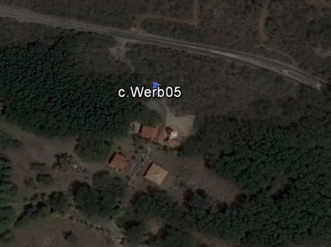 |
Santa Cruz Grave (Was: Werbata Candidate #5) (GPS: c.StaCruz) |
Santa Cruz 12deg 18' 19.98" N 69deg 8' 7.08" W |
NOTE: I have not yet visited/photographed this burial site. A single grave on private property that was the sugar mill. It is located behind a locked gate labeled 'HOFI MANGO Sta CRUZ'. Santa Cruz was a former sugar and mango plantation. Jan H.R. Beaujon (on my FB page, 190821) reportedly knows the previous owner. He was told that the grave was for a Typhus victim in the 1920s who worked at the sugar mill, and was buried locally because of a prohibition on moving bodies of victims of the contagion. Grave seems pretty ornate (half-cylinder top) for a simple worker, so perhaps an owner or member of owner's family? As of August 2019, the property is for sale for US $1.4 Million. https://century21numberone.com/en/curacao-real-estate/property-view/1125778/?fbclid=IwAR1tUbdHuzK-A0rhRAXj6O08pFxVhfYOD-ZRs92j6kSgy-acG3mRDgMLpE4 There is a low-resolutiion video of the property which briefly shows the half-cylinder-top grave in passing. https://www.youtube.com/watch?v=P0zzMJkXsKc&feature=youtu.be&fbclid=IwAR3gkqCeNsSukIk-ZcKsjHtZwMQc0sIxARovmxT1Og3GpNUOTLgfeZWR9tE Formerly 'c.Werb05'. NOTE: This single red cross on Werbata map "02c_II.jpg" (lower left) has the notation "Graf" ("Sulpuchre" in Dutch). |
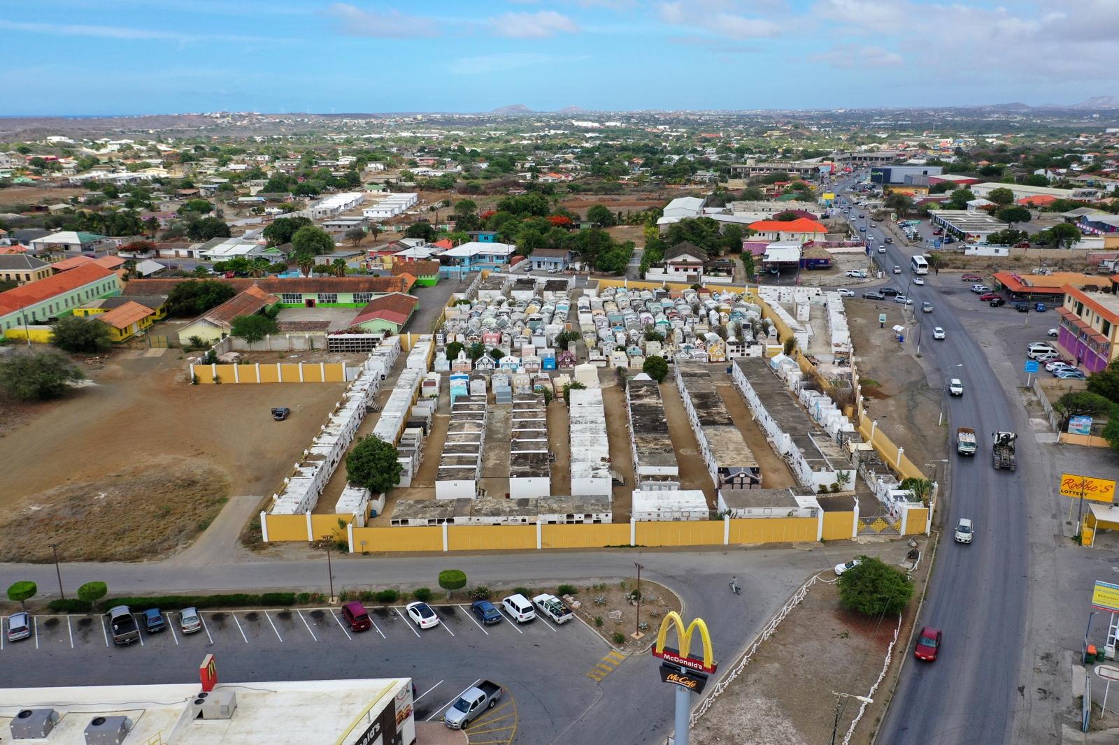 |
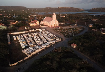
Santana Santa Maria Church of Maria Auxiliadora (GPS: c.StaMaria) |
Salsbach / Winston Churchillweg 12deg 9' 21.46" N 68deg 56' 32.93" W Telephone: +599 9-868-2227 |
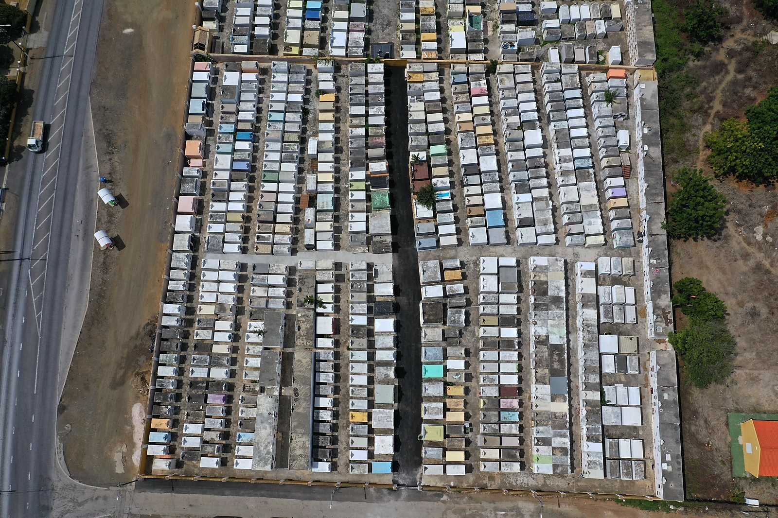
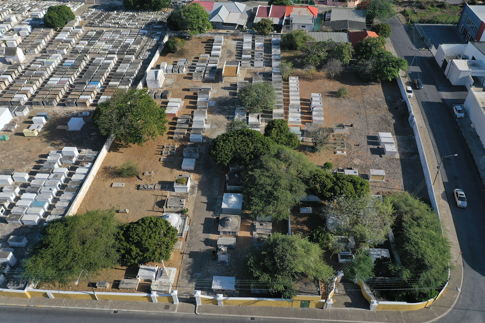
Located on Winston Churchillweg, next to the church and McDonalds. Separated from the church by a parking lot, roadway, and large empty space. The gate on the church side has an unlocked 'man door' to allow visitor access. When I was there, there were several individuals and family groups coming and going. This is a large cemetery, mostly modern with most dating back no further than the 1950s. I did find one grave, overgrown by a tree and breaking up, that appears to be dated 1933. (Photos taken). "Gerarda Warda Placides NACE 4 October 1876 MURI 7 October 1933 R.I.P." Rows are identified by letters of the alphabet, with the later letters on rows of tall crypt assemblies. Each crypt has an assigned number. The lowest numbers (oldest crypts) seem to be on the Eastern wall of the cemetery. Not a great deal of statuary or art associated with the crypts, but some, and many many crosses atop crypts. Some of the layout is haphazard, with small passages between crypts, especially in the older (lower numbered crypts) areas. One small row along the wall with Gate #1 was exclusively children, in modern burials (1990+). That row was hidden a bit behind row V. Ground photography July 4, 2015. Drone photography July 13, 2019. |
 |
Santa
Rosa (Catholic) (GPS: c.StaRosa) |
Santa Rosa 12deg 6' 34.67" N 68deg 53' 43.93" W Contact: |
At Santa Rosaweg and Weg Naar Sta Catherina. A medium to large cemetery, still with active burials. Gate is in parking lot adjacent to the church (Parokia Santa Rosa di Lima), and the lock and hasp do not appear to indicate that the gate is ever locked. Ground photography July 7, 2016. Drone photography July 11, 2019. |
|
|
Soto Cemetery
(GPS: c.Soto) |
Soto 12deg 16' 32.51" N 69deg 6' 35.60"W Contact: +599 9-864-1801 |
Located in the small village of Soto, in the Western end of the island ("Banda Abou"). The gate on the road side is normally locked, but the gate on the church side is secured with rope/wire, but is normally unlocked. Ground photography July 7, 2015. Drone photography July 8, 2018. |
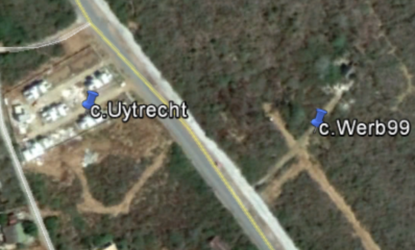 |
Uytrecht Grave
Adolf van Uytrecht died 1902 (GPS: c.Uytrecht) |
Near Daniel 12deg 12' 31.21" N 69deg 1' 11.39" W (Very Approximate Coordinates) |
NOTE: I have not yet visited/photographed this burial site. Located approximately 300m North of the intersection of Weg naar Westpunt and Weg naar San Willibrordus, just South of Landhuis Daniel on the West side of the road. This grave is marked on old maps as "Grave Adolf van Uytrecht". Googling finds a description and photos of the site that state that nothing but scattered stones remain of the grave(s). http://curacaopictures.com/nl/natuurwandelingen/22-topcategorie-nl/fotos/historische-locaties/overig/211-kleine-berg-graven-bij-daniel-en-pos-di-wanga?hitcount=0 |
|
|
Westpunt Cemetery (GPS: c.Westpunt) |
Westpunt 12deg 22' 14.40" N 69deg 9' 5.58" W Contact: |
This cemetery is located on the West end of the island ("Banda Abou"), in
the fishing village of Westpunt. This is the cemetery furthest West on the
island. There is a locked gate on the main road on the East side of the cemetery, and a locked service access gate on the West side (which does not appear to have been opened recently: very rusty lock!). In my first visit in 2009, front gate was unlocked. At the time, I was not yet interested in documenting Curacao Cemeteries, and I only took a few photos as I walked through the cemetery as a tourist. At the time, the cemetery paths and some of the crypts were overgrown. I visited during later years, and the gates became locked several years ago. Gaps in the fence allowed access for more extensive photography in July 2019. The paths were all clear and the vegetation trimmed. Photos in the album include those from 2009 and 2019. Ground photography January 26, 2009 and July 3, 2019. Drone photography July 7, 2018. |
|
|
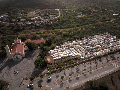
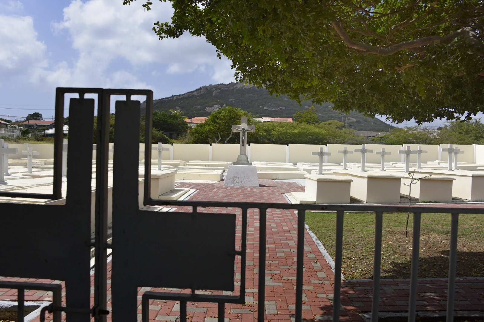
Sint Willibrordus Catholic Church & Cemetery
(GPS: c.Willibrordus) |
San Willibrordus 12deg 13' 0.06" N 69deg 3' 55.32" W Telephone: +599 9-864-8330 |
Located near Jan Kok, this small cemetery is adjacent to the picturesque
church in Willibrordus. The gates are normally locked, but I visited with another cemetery photographer during a period when construction/mainteance work was underway. Ground photography July 7, 2015. Drone photography July 7, 2018. |
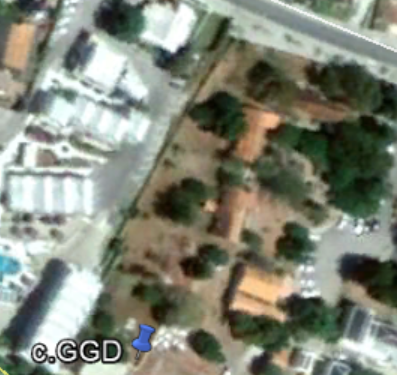 |
Zaquito: Cemetery of Sisters at Zaquito "Begraafplaats van Zusters bij Zaquito" (GPS: c.Zaquito) (Was: c.GGD) |
Mundo Nobo / Zaquito 12deg 6' 49.36" N 68deg 57' 21.40" |
NOTE: I have not yet
visited/photographed this burial site. Past the Coromoto Church in Mundu Nobo. At back of property at Piscaderaweg 49, GGD (Geneeskundage en Gezondheidsdienst - 'Medical and Health Services) 'Begraafplaats van Zusters bij Zaquito' - 'Cemetery of Sisters at Zaquito'. It appears that there was a leper hospital at this site (known to be active in 1946), and the graves appear to be the religeous sisters who gave care. Not known if any patients were also buried at this site. [NOTE: An early hospital for lepers was established in the 1770s, although not at this site.] |
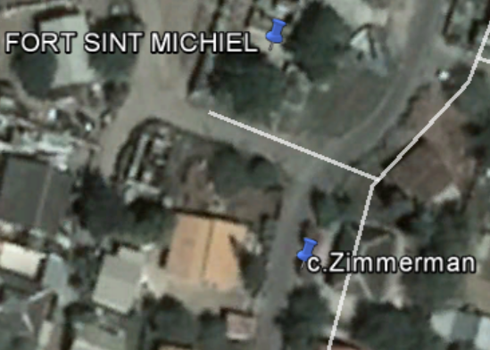 |
Zimmerman Grave Christiaan Zimmerman (GPS: c.Zimmerman) |
Boca Sami /Sint Michiel 12deg 8' 41.64" N 68deg 59' 56.46" W In private garden, viewable from road through wall. |
Photos of the single grave of Christiaan Zimmerman (1799 - 1873). This grave is located in the garden of a house Southest of Firt Sint Michiel on Redeweg in Boca Sami / Sint Michiel, inside a wall. The homeowner has provided a cut-out in the wall with wrought-iron ornamental scrollwork in it to allow a view of the crypt from the roadway. Zimmerman was born and died in Curacao, and was the father of 12 children. More photos at TripAdvisor.com: https://media-cdn.tripadvisor.com/media/photo-s/0d/1f/bb/67/grab-von-chritiaan-zimmerman.jpg Ground photography July 8, 2019. Drone photography has not been done as yet. |
|
Zjanpa Grave (GPS: c.Zjanpo) |
Boca Sami /Sint Michiel GPS Coordiates Unknown Reported in private garden. Ask local residents where it is! |
NOTE: I have not yet visited/photographed this burial site. During the discussion on Facebook of the Zimmerman grave, a user says that there is a second single grave in Sint Michiel/ Boca Sami in a private yard, and claims that anyone in the village can point me there. In July 2019, I was unable to find anyone who knew where it was located. |
|
| These 'Werbata
Candidates' are burial sites marked with red crosses on the Werbata
topographical maps, which were created between 1900 and 1910. These sites
are not currently-known or recognized (by me) burial sites. Others with more
historical perspective might be able to attach names and information for
these sites. The GPS coordinates for all of these are very approximate. When time allows, I'd like to explore these sites. |
|||
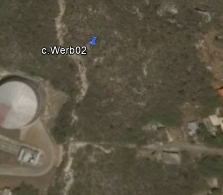 |
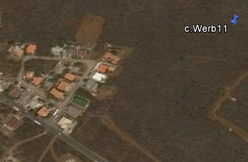
Werbata Candidate #2 (GPS: c.Werb02) |
12deg 7' 16.25" N 68deg 57' 16.98" W From Google Earth and approximate coordinates, this site may be at the base of a cliff behind a housing area. |
NOTE: I
have not yet visited/photographed this burial site.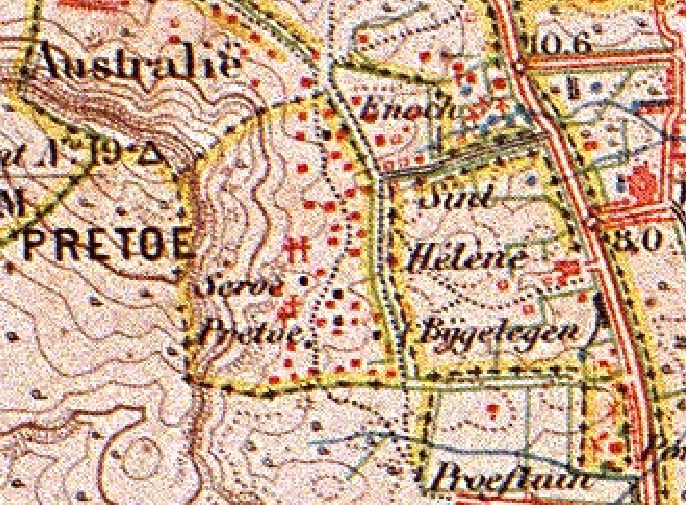 |
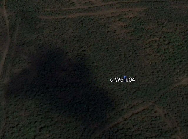 |
Werbata Candidate #4 (Single Grave?) (GPS: c.Werb04) |
Christoffel Park 12deg 19' 33.6" N 69deg 6' 56.4" W (Very Approximate)
|
NOTE: I
have not yet visited/photographed this burial site.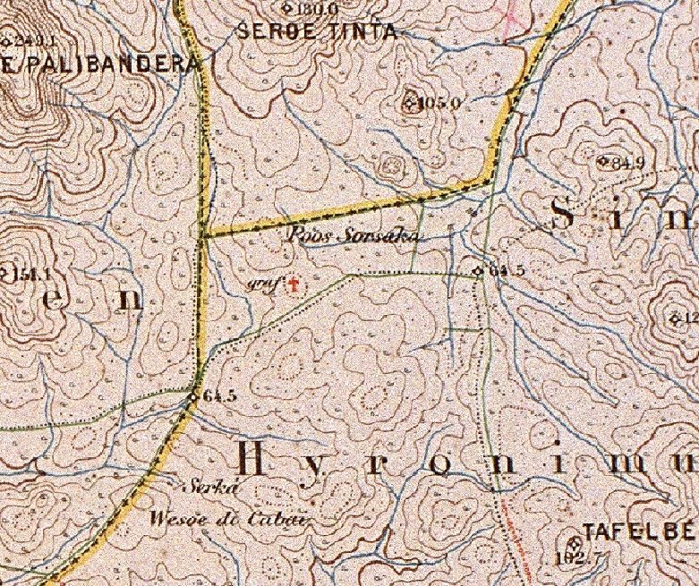 NOTE: This single red cross on Werbata map "02c_II.jpg" (upper right) has the notation "Graf" ("Sulpuchre" in Dutch). It may be a single crypt or a small collection of crypts. |
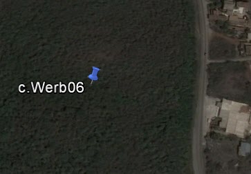 |
Werbata Candidate #6 (Single Grave?) (GPS: c.Werb06) |
San Mango? 12deg 17' 26.46" N 69deg 7' 36.36" W (Very Approximate) |
NOTE: I
have not yet visited/photographed this burial site.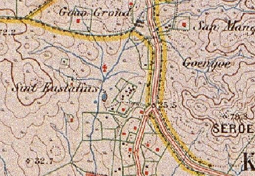 NOTE: This single red cross on Werbata map "04b_IV.jpg" has no notation. It may be a single crypt or a small collection of crypts. |
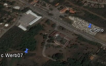 |
Werbata Candidate #7 (Single Grave?) (GPS: c.Werb07) |
Soto 12deg 16' 28.64" N 69deg 6' 43.00" W (Very Approximate) |
NOTE: I
have not yet visited/photographed this burial site. NOTE: This single red cross on Werbata map "04b_IV.jpg" has no notation. It may be a single crypt or a small collection of crypts. It is possible that any grave(s) here were moved to Soto Cemetery when it was established a bit NE from this spot. |
|
|
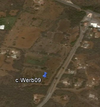
Werbata Candidate #9 (Single Grave?) (GPS: c.Werb09) |
Dokterstuin 12deg 16' 27.36" N 69deg 4' 25.44" W (Very Approximate) Single grave? From Google Earth, looks like it may be in a planted field? |
NOTE: I
have not yet visited/photographed this burial site.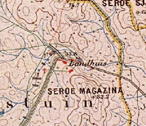 |
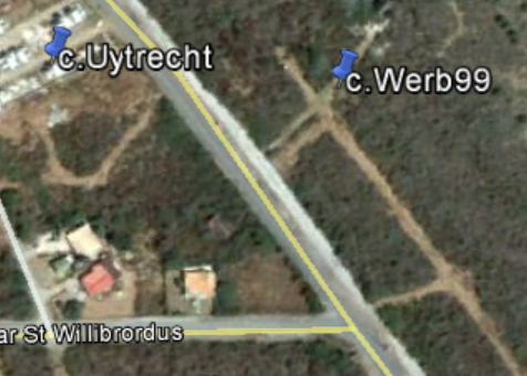 |
Werbata Candidate #99 (GPS: c.Werb99) |
Near Daniel Very Approximate Coordinates 12deg 12' 31.0" N 69deg 1' 5.68" W Seen on 1908 Werbata detail map "08a_VIII.jpg". Located just WSW of c.Uytrecht, just South of Landhuis Daniel. |
NOTE: I
have not yet visited/photographed this burial site.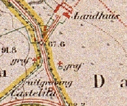 |
| These 'Candidate
Cemeteries' are wild-ass guesses at areas seen on Google Earth satellite
images that resemble cemeteries. They may be parking lots, junk yards, or
almost anything else. (I had once identified the 'Campo Allegre' brothel as
a possible cemetery!) When time allows, I'd like to explore these sites, and will eliminate them when they prove to be other than cemeteries. |
|||
 |
Candidate Cemetery #3 (Name Unknown) (GPS: c.Cand03) |
Willemstad (Motet) 12deg 6' 35.98" N 68deg 55' 29.81" W Contact: |
NOTE: I have not yet visited/photographed this burial site. |
Copyright (c) 2019 Jeffrey A. Maass
All Rights Reserved.